
MESSAGE BOARD
THE CHALLENGE COMMUNITY, ON-LINE!
FRIENDLY ASSISTANCE AND ENCOURAGEMENT AVAILABLE FOR CHALLENGERS OLD AND NEW,
FROM FRIENDLY AND ENCOURAGING CHALLENGERS, NEW AND OLD
PLEASE USE YOUR OWN NAME WHEN POSTING. THANK YOU!
Download route sheets, admin forms, event documents here
Any queries? Email the coordinators Sue, Ali & Mick at tgochallenge@gmail.com
Festive greetings to you all,
I know there are some knowledgeable challengers here, so I'm wondering if you can help with route advice. I did one successful challenge in 2017 and I like to think I've got a good amount of outdoors/mountain experience. So I'm thinking of submitting a route that starts by heading east from Morar through Bracora, Tarbet and beyond.
The route to Tarbet (NM 792 924) seems straightforward. From there, it looks reasonable, although steep, to climb up to the top and follow the ridges, before descening, at some point, to Glen Dessary. However, this leaves me with questions about a FWA / easier option. I have read some vague reports that it is possible to walk east from Tarbet along the south side of Loch Nevis to Finiskaig (NM 870 947) and the river of the same name, i.e. with the view to reach Glen Dessary and the map-marked tracks along Loch Arkaig. Some say that you need to do it at low tide and that it's not difficult, although a bit rough in places. Can anyone confirm?
Many thanks and best wishes,
Rob Scovell.
Hi Rob,
Loch Nevis shoreline always proves a conundrum, being the obvious FWA when starting from Morar. I've done it once, not on the Challenge, back in the eighties, two of us walking from Bracora and sticking close to the shore. The map doesn't lie and you'll enjoy good tracks and paths as far as Kylesmorar, which might sew a false sense of security. The ongoing route certainly can't be described as easy, the terrain tussock ridden and vegetated, with countless ups and downs to avoid obstacles such as burn ravines and crags. There are places where vertical rock faces plunge into the loch, which perhaps explains the reference you've mentioned to low tide, though in my recall there are sections where the shore encounters deep water, so you'd still face occasional ascents. It's difficult to retrace our route from so long in the past but I'd estimate that we may have clocked up a substantial ascent figure as we progressed along the loch, perhaps as much as 300m.
There are compensations; at several points, you pass old settlements where you can still pick out strips of improved pasture and those are all beautiful and poignant settings. One couple whose route I vetted last year reasoned that these settlements must have been joined by paths. That may be true but my suspicion would be that most transactions would be carried out by boat and that any old routes will long have vanished into the undergrowth. We certainly didn't locate any.
I'd suggest that the route is do-able as long as you know what you're in for and are prepared for very slow progress. Attempting to stay low will probably not work and a line at the 50-100m contour would be wiser. The main problem will be that you're adding it as a FWA so, by definition, the weather conditions may be very unpleasant. We were lucky enough to tackle the difficulties in decent conditions; I'd imagine that in driving rain and high winds it might be purgatorial.
In contrast, though I haven't done it myself, reports of the ridge route are generally positive and many have praised its high quality and views. I did get feedback from one lady who found the approach route to the ridge, from the track to Tarbet, a little tricky. She mused that a better route might be to ascend from Kylesmorar and miss some intervening roughness.
In conclusion, whether you enjoy the Loch Nevis route will depend on your own level of experience and your stamina for difficult terrain. If the above comments don't put you off then go for it. The route to avoid, I believe, is the shore of Loch Morar, reportedly much harder. I'm usually a glutton for punishment in that respect but even I have been firmly put off.
Hope that helps.
Colin
Hi Colin,
Many thanks for your reply.
It does look like these routes, perhaps through Kylesmorar, would be enjoyable in good conditions.
I'll have a think about this and consider other options for FWA. If the forecast is bad then a multi-day FWA avoiding North Morar altogether might be the best option.
All the best,
Rob.
Hi Rob,
Yes, you've done one Challenge and now you have chosen to start from Morar, our hardest start point, so that's very brave. I've done the route over North Morar twice. The first time was back in 1999 (?), but then we started from Arisaig. My wife Suus and I arrived in Morar at 11.30 hrs., had a coffee at the Morar Hotel and went off at 12.00, Eastwards over North Morar. Along the North side of Loch Morar via Brinacory and Swordland to Tarbet is indeed a good walk.
We got there at 16.00 hrs. and carried on over a good path down to Kylesmorar. But then it was over: I should say the walk along the South side of Loch Nevis is quite impossible.
At least, as Colin says, progress is very slow and you have to go many times off coast, uphill and down again. My advise: don't go this way. Anyway, we went up along the little burn to Lochan nan Tri-chriochan and further uphill SE. It went rather slow, but it's do-able.
At 19.30 hrs. it was done - both very tired, so we camped between the little lochs at NM 818 923. Fortunately: the weather was good and quiet. But we had planned Finiskaig for day 1 ; it took us another 3 1/2 hours to get there next day, and had to decide to stay over in A'Chuil bothy, still half a day behind our scheme.
My second one was in 2017, on my own, and started at 9.00 from Morar. With the experience from 1999 in mind, I thought Finiskaig I can get to on day 1.
Anyway, after a lunch stop, I left Tarbet at 14.00 hrs. I was joined by a walker from Scotland and in front were a father and son from England. My vetter advised me to make a shorter route, not down to Kylesmorar,but uphill direct from the bend over Druim Chuillinn, to Cnoc a'Bhac Fhalaichte. Steep and rather boggy - hard work. After a couple of hours, near Coire Dubh, the (English) father said he had enough and they decided to go down to Loch Morar, let's say in direction of Sron Mhor / An Romasaig. Their intention was Kinlochmorar. So I went further on my own, still heading for Finiskaig to camp there on the Friday night. But it was still a real struggle. And indeed, at approx. 19.15 hrs. it was over: totally knackered and exhausted.
So I pitched just West of Sgurr Bhreac: in my tent I had cramp in my right leg for 20 mins.
Next morning: got up at 6.00 hrs. and left just before 8 o'clock. In half an hour I saw a tent between the little lochs on Lag Lain, it was co-vetter Ian Cotterill (still in his sleepin'bag). Weather was still fine, dry and no wind. I carried on over Sgurr nam Meirleach and then the very steep and dangerous descent over the Bealach nan Daoine to Finiskaig. You have to be very careful, especially when you are on your own!
Anyway, arrived at 11.00 hrs. at Finiskaig, had a stop for 45 mins. and saw Ian Cotterill coming down from Sgurr nam Meirleach. A few hours later we met and had a stop near Lochan a Mhaim in Glen Dessary. And around 3 o'clock there were 2 Challengers coming from the right, near Upper Glendessary: they were the father and son who left down to Loch Morar the day before! We walked on together for an hour or so, then they went straight od from Strathan , minor road along Loch Arkaig. I went left, NE along Dearg Allt, to arrive at 19.15 at Kinbreack bothy after a second long day.
Conclusion: you can do the walk from Tarbet, best way is over the ridge and down to Finiskaig from Sgurr nam Meirleach (or further E over the ridge, Sgurr na h-Aide and Meall na Sroine down into Glen Dessary). And then FWA: I'll say there is no real FWA - both times I didn't plan one. I think that going down to Loch Morar. just West of Sgurr Mor, is an option. Looking on the map, I think the last 3 km. to Kinlochmorar from Sron an Drutain (ruin)is very well do-able.
Finally I will tell you how my 2017 Challenge ended. Day 2, at Kinbreack, was another long day (too long). Still behind scheme, I had to do 37 km. to Invergarry. I left the bothy on time, the route is flat, but very long. Anyway: I arrived at Invergarry Hotel at 19.30 !
3 very long days, felt exhausted again, an had problems with my toes on both feet. And I waited too long to pay attention on the feet. Day 4 was just 12 km. along the Caledonian Canal to Ft. Augustus, arrived at 14.00 hrs. but I didn't feel very well. Didn't have a meal that night, just a couple of drinks. And ....... day 5 and 6 were another 65 km. over the Monadliath, via Glen Doe, Glen Markie, Findhorn and Dulnain to Kingussie. On Tue. night I camped in upper Glen Markie and then I decided to retire at Kingussie.
I met co-vetter Colin Crawford in upper Glen Findhorn, not far from Dalbeg, I told him my story and he said he had the same feeling (but he carried on and completed this one).
To myself: this was not good planning for an experienced walker and vetting routes for more than 10 years. And this happens on my 19th crossing !
Anyway: I completed my 19th crossing in 2019 and then looking forward to my 20th in the year 2020. And then came Covid-19 - so the 20th will - hopefully - be in 2021, in another 5 months.
Well good luck Rob, I wish you all success (maybe we can meet, because we have planned to start from Mallaig).
Bert Hendrikse

Hi Rob
RIGHT CLICK TO ENLARGE
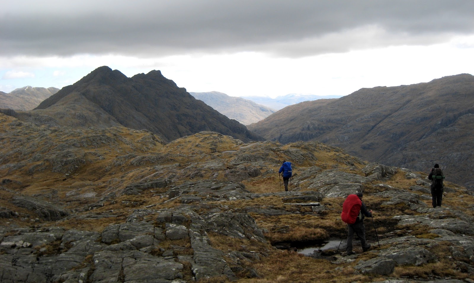
I went this way in 2012 with Mad'n'Bad and Wee-Willy-Wilky. I didn't realise it at the time but I was quite unwell with a blood count of 87 and so I wasn't firing on very many cylinders. However, we managed it by plotting a route to A' Chuil that would take two days.
You can see how we coped by clicking on the following two links where you'll find the maps and route we took along with descriptions of the days:
DAY 1: Morar to Coire Dubh
DAY 2: Coire Dubh to A'Chuil
RIGHT CLICK TO ENLARGE
I wouldn't bother with an FWA for the North Morar Ridge. Take it direct and if the weather closes in take the escape route down Leac Bhuidhe that we took. If I could do it well below par, a fairly fit Challenger should breeze it.
As an aside, the incredibly fit and capable John Hesp continued for the full length of the ridge and found the descent to be quite harrowing. However he took a better ascent line by starting from Kylesmorar rather than clambering up Druim Chuilinn and its precarious stiles over deer fences.
Whatever you choose, good luck The views are stupendous!
Alan
"....the incredibly fit and capable John Hesp...."
Well that's a handsome comment in these dreary times. Thank you Alan.
That day was one of the most memorable in the four Challenges I did. I didn't actually get to the end of the ridge, but injured myself slightly descending Bidein a' Chabair, so dropped down into the glen to the south.
The whole ridge is superbly rugged with fantastic views in all directions - highly recommended to those considering it.
More info on my day here:
http://www.hesp.co.uk/trips/tgoc/jh_2012/day_02/day_02.html
Hi Rob,
Back in 2013 I had the same question (but starting fom Malaig). With no feasible FWA available decided the ridge was not for me. Ridges are not my prime interest, I started to do some reading on Morar and found out that travel around these shores was mostly by boat, both on Loch Morar and Loch Nevis. Interesting is though that the North shore of Loch Morar was often used as direct overland route to Tarbert by the wives of the crofters at An Romasaig and Kinlochmorar. When the herring was in season labour was very much in demand in Tarbet. A very welcome extra income for the Loch Morar crofters who could not direct benefit from the yearly herring trek. They seem to have used the route from An Romasaig up through Coir' a' Bhealach and Coire Dubh then down to Tarbet. (see OS 1:25.000 for some of the names).
This raises the question if there is a feasible walking route between An Romasaig and South Tarbet Bay, since there where on some points in time more small communities in between, Especially around Cuil a' Mhuic. All with south facing slopes more suitable for crofting then the communities facing North on Morar's Loch Nevis shore.
So this all lead to Loch Morars North shore being my main and foul weather proof route on my 2013 challenge, which in the end was approved by my vetter. Reading your question it occurred to me I never submitted a report on the route to the vetters as I promised. So maybe this is the time and place to do it.
Basicly the route from South Tarbet Bay to Kinloch Morar is very well doable though in places rough and wet. Even on a very wet day as it was in 2013. The only obstacle is Sròn Mhor, but I'll come to that.
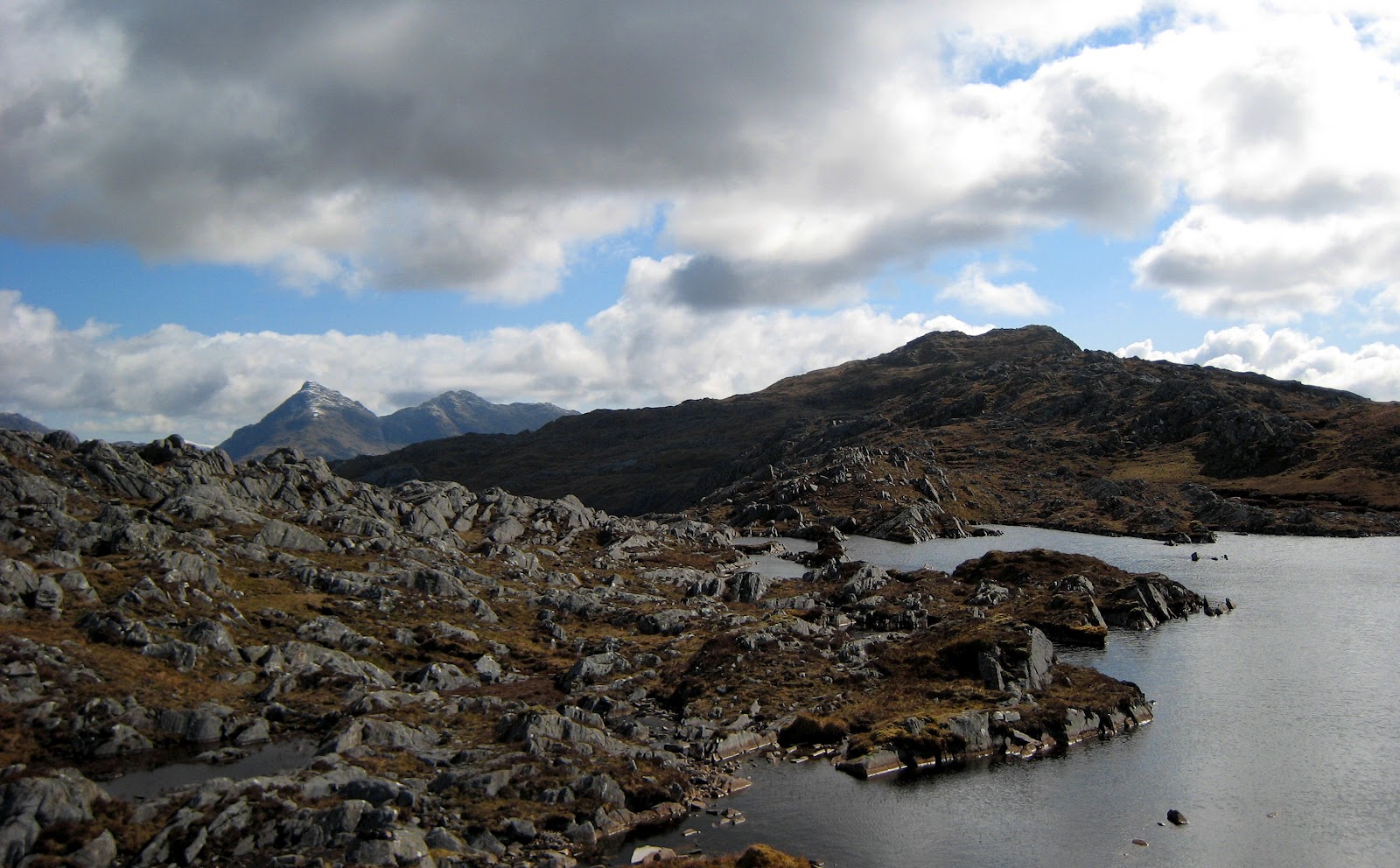
When you reach the Tarbet path from Swordland turn right to South Tarbet Bay. Soon you will see the trees from Glac Falaichte. Work your way over a broken wall and cross the streams (easy) over to the far north-east corner of the trees. An old gate gives access to the open hill. From the gate a faint and rough but clearly path goes East at some height above the shore. The path has traces of an overgrown but well build track of old. This will lead you to some ruines on a knoll (Cuil a'Mhuic). The track ends here. From the knoll a small path (more like deer and sheep tracks) continues, more or less on the same level. After awhile you will loose the poath and meet some very large and overgrown blocks. This is Stròn More blocking your way. The blocks are very solid and save. The difficulty is only about 100 meters long. Stay on the same level and work your way carefully around a corner and the path re-emerges en soon opens out to An Romasaig. I sounds more difficult that it actually is. I needed only twice a hand to hold. A small reconnaissance with no backpack gave us an easy route through within a couple of minutes.
An Romasaig is an interesting place, we camped close to the shore, though level places are very few. From her to Kinlochmorar is straightforward, with Sròn a' Drutain posing no problems whatsoever. See the piccies.
Weather this works for you is up to you. For me it is the only usable FWA avalaible for starts from Malaig or Morar. Since, apart from the above mentioned early exit from the plateau through Corie Dubh, any other exit further on is too steep in any weather for my taste.
I hope this helps
Rolf
Hi All,
I'm very grateful for these detailed route suggestions. It will take me a little time to process all of this. It is reassuring that, while not easy, there are many reports of successful crossings through North Morar.
Will send an update when I've got a bit further with the map studies.
Cheers,
Rob.
Thanks again everyone for the suggestions and for the encouraging pictures!
There seems to be plenty of options. Probably will submit something like the route at end of this message. Even if the weather's good, going up to Coire Dubh and then down to An Romasaig (FWA #1 below) appears the most straightforward option, if I'm not feeling up to the ridge walk.
Cheers,
Rob.
P.S. Bert, I think I did meet you briefly at the end of the 2017 challenge but might not have introduced myself. You vetted my route that year. If we're likely to be somewhere near Mallaig at the same time, it would be great to chat with you about the routes.
Day 1
--------------------------------
Morar -> ... -> North Tarbet -> Kylesmorar -> Ascend to Coire Dubh (NM 813 919; camp)
FWA: None
Notes:
The route up to Coire Dubh looks easier from Kylesmorar (according to Colin's challenger feedback), rather than directly from Tarbet.
Day 2
--------------------------------
Ideal conditions: Coire Dubh -> Sgurr Mor -> Sgurr Breac -> Sgurr na ba Ruidhe -> Sgurr nam Meirleach -> Sgurr na h-Aide -> Bidein a' Chabair -> Meall na Sroine -> Descend E down to Glen Dessary -> A' Chuil
FWA #1: Coire Dubh -> An Romasaig -> Sron an Drutain -> Kinlochmorar -> A' Chuil
FWA #2: Coire Dubh -> Sgurr Mor -> Sgurr Breac -> Sgurr na ba Ruadhe -> Sgurr nam Meirleach -> Bealach nan Daoine -> Coire Dubh -> Finiskaig -> Sourlies or A' Chuil
FWA #3: Coire Dubh -> Sgurr Mor -> Sgurr Breac -> Sgurr na ba Ruidhe -> Descend Leac Bhuidhe -> Glean an Lochan Fanaiche -> A' Chuil
Notes:
FWA #1 follows the North coast of Loch Morar but avoids the awkward Sron Mhor, as mentioned by Rolf and Bert.
FWA #2 includes more of the ridgeline with exit by descending along Bealach nan Daoine, as Bert mentioned.
FWA #3 includes more of the ridgeline with exit by descending along Leac Bhuidhe, as Alan's route shows.
Questions:
Where to exit the ridge if conditions/fitness are good enough to follow ridgeline further?
- From Meall na Sroine: East face descent.
- From Meall na Sroine: N decent along Allt na Sroine.
- From Bidein a' Chabair: NE following Druim Coire nan Laoch and Creah Mor nan Lochan.
This video has a group that used the North side of Loch Morar option then on to Glenpean.
https://www.youtube.com/watch?v=575ZScVYSsU
Another Morar blog - https://janetswalks.blogspot.com/2020/02/tgo-2019-morar-to-catterline-9th-may.html
I confess to being the lady who mused about an approach from Kylesmorar rather than the high spot of the track to Tarbet. For interest - having read about the problems of FWAs along the shore of the ridge - I had a completely different 2 day FWA though South Morar to Meoble, Loch Beoraid and Gleann Chaorainn. Didn't have to use it but I rather like the look of it
Hi
Nice footage.
at 4.23 the most scary part of Srón Mor and at 4.25 entering An Romasaig. Compare that to the passage of Sron a Choin at 4.32 or the passage of Lochan Leum an t-Sagairt in Glen Pean at 4.36.
Have fun and stay save
Rolf
Thanks Janet and Phil,
That's really helpful.
Based on the video and Rolf's information, I think I'd be comfortable with the north shoreline of Loch Morar. As others have said, descending from the ridge is a bit steep and dangerous, so I'll abandon that idea. The aim will be to camp at Kinlochmorar on Day 1.
Best wishes,
Rob.
Be very careful along the north shore of Loch Morar as in places there are shear drops into the loch, which is the deepest in Scotland! Rather than try to stay by the shoreline, from Tarbet Bay, stay up and back from the shore to save continual climbing and descending. If you are camping at Kinlochmorar then take care crossing the Abhainn Ceann-loch-morair as it is quite deep and in spate very dangerous.